Yeosu becomes first city in South Jeolla Province to introduce 3D drone video simulation system for cadastral resurvey project
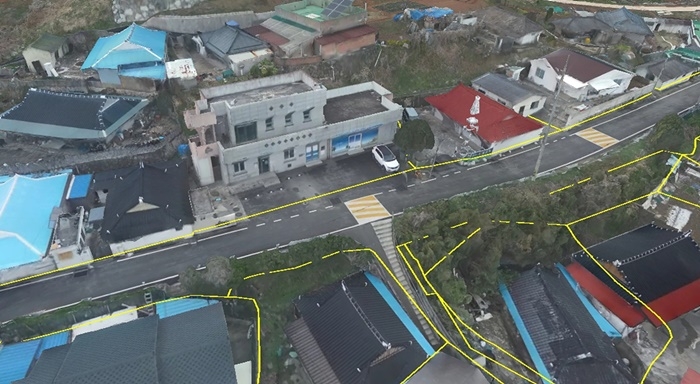
Yeosu has become the first city in South Jeolla Province to introduce a 3D drone video simulation system and deploy it in an active cadastral resurvey project.
The cadastral resurvey is a national government project aimed at replacing hand-drawn paper land maps dating back more than a century to the Japanese colonial era with modern digital surveys, improving accuracy and reducing land disputes.
The city, led by Mayor Seo Yeong-hak, completed the "3D high-precision drone video boundary-determination simulation system" last year, targeting the Deuksil district in Yulchon-myeon as its pilot site, and has since moved into full operation.
Conventional 2D flat drone imagery has limitations in capturing three-dimensional terrain information — such as elevation differences, retaining walls and overhanging building eaves — forcing repeated on-site reinspections during boundary determinations and creating administrative inefficiencies.
The newly introduced 3D simulation addresses those shortcomings by enabling multi-angle analysis of terrain features.
When a resident designates a specific point of interest, the system renders the slope and structures at that location in three dimensions and overlays the actual cadastral boundary lines, offering a citizen-tailored service that lets landowners grasp boundary determinations at a glance.
Yeosu plans to apply the system starting with a residents' briefing for the Yulchon Deuksil district, aiming to improve landowners' understanding of boundary decisions and advance a more transparent and trustworthy cadastral resurvey process.
"We will lead the way in improving the accuracy of boundary determinations to reduce related disputes and protecting citizens' property rights through cutting-edge cadastral administrative services," a city official said.
parkds@heraldcorp.com