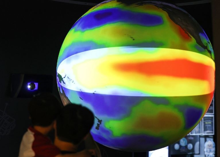
The El Niño event that developed this year is expected to intensify further, reach its peak at year-end and persist at least into early next year, according to the latest forecasts. Unusually high sea surface temperatures across the tropical Pacific are raising the likelihood of significant disruptions to temperature and precipitation patterns around the world.
The World Meteorological Organization placed the probability of El Niño conditions continuing from September through November at virtually 100 percent in its El Niño/La Niña outlook released Thursday. It put the odds of El Niño persisting from December through February at nearly 100 percent as well. Such high-probability forecasts for El Niño continuation are rare for the WMO.
"There is no prospect of a return to neutral conditions or La Niña during the outlook period," the WMO said. "El Niño intensity is expected to increase further, developing to a very strong level and reaching its peak at year-end."
The organization added that "a very strong El Niño will increase the likelihood of significant departures from normal temperature and precipitation patterns in many parts of the world."
In its seasonal outlook for September through November, the WMO projected that sea surface temperatures in the El Niño monitoring zone of the tropical Pacific would remain well above normal, driving further intensification. The WMO's multi-model average forecast puts the sea surface temperature anomaly in the Niño 3.4 region at around 3.6 degrees Celsius during that period.
El Niño refers to the abnormal warming of sea surface temperatures in the central and eastern tropical Pacific. The standard benchmark is a three-month average sea surface temperature anomaly of at least 0.5 degrees Celsius above normal in the Niño 3.4 region.
This year's temperature rise is itself exceptional. According to the Korea Meteorological Administration, sea surface temperatures in the monitoring zone are currently running about 2.6 degrees Celsius above normal. When the anomaly exceeds 2 degrees, the event is sometimes informally called a "super El Niño."
However, the WMO does not use the term "super El Niño" in its official classifications. Instead, it categorizes events by intensity as weak, moderate, strong or very strong. The current event is expected to reach the "very strong" level.
Some climate prediction models suggest this El Niño could rival or even surpass the powerful events of 1997–1998, 2015–2016 and 2023–2024. The WMO cautions, however, that El Niño intensity does not directly translate into the scale of impacts in any given region, as local effects depend on Indian Ocean sea surface temperatures, atmospheric circulation and other climate factors.
A key concern is that a strong El Niño is coinciding with already elevated global average temperatures. El Niño tends to temporarily push global mean temperatures higher by releasing heat stored in the tropical Pacific into the atmosphere.
In its medium- to long-range climate outlook released in May, the WMO put the probability of at least one year between 2026 and 2030 surpassing 2024 — currently the hottest year on record — at 86 percent. It noted that as El Niño develops toward the end of 2026, the likelihood of 2027 setting a new temperature record could grow.
El Niño's effects extend beyond temperature. Depending on the region, it can sharply increase the risk of heavy rainfall and flooding, or conversely worsen drought conditions. The WMO notes that strong El Niño events tend to bring increased precipitation to parts of South America and East Africa, while driving drier conditions in Australia, Indonesia and southern Africa.
Extreme weather also has direct economic consequences. In Latin America, for instance, drought can lower river and reservoir levels, disrupting agriculture, hydroelectric power generation and transportation. Repeated drought and low water levels at the Panama Canal could restrict vessel traffic and ripple through global supply chains.
South Korea also tends to experience warmer-than-normal winters with higher precipitation during strong El Niño events. However, the country's actual winter weather is not determined by El Niño alone — sea surface temperatures in the Indian Ocean and western Pacific, Arctic sea ice, the Siberian high and other factors all play a role simultaneously.
Even if this El Niño develops into a historically powerful event, it is therefore difficult to say with certainty that South Korea will see a warm, wet winter. Still, with El Niño now more likely to intensify through year-end, the broader risks of extreme weather — heat waves, droughts and heavy downpours — are growing worldwide, and the knock-on effects on agricultural prices, energy demand and logistics costs are expected to widen.
rainbow@heraldcorp.com